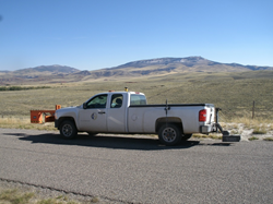
Resource International, Inc. Uses Non-Contact High-Speed Ground Penetrating Radar (GPR) To Measure Pavement Layer Thickness at The Network Level


Columbus, Ohio (PRWEB)
July 01, 2015
During a recent project for the University of Wyoming, Resource International, Inc. (Rii) used Ground Penetrating Radar (GPR) to conduct pavement surveys rapidly, non-destructively, and with no traffic disruption or safety risks.
Pavement thickness is needed for pavement management and rehabilitation. It represents an important element of a pavement management system and it is essential for load rating, overlay design, and setting maintenance and rehabilitation priorities. Accurate pavement thickness data is important information to have at the network or project level. This information is most of the time missing, out of date, or unknown to the state or county engineers.
As in many other northern states with industries pursuing oil and gas natural resources, the paved and unpaved road networks in the 23 Wyoming counties are midst of joining this national trend in transition from a purely local, low volume community and recreational infrastructure to serve modern industrial activities of oil and gas drilling. The industrial activities of oil and gas drilling produce a higher volume of traffic with often greater frequency, high percentages of industrial vehicles and significantly heavier loads.
The Wyoming Technology Transfer Center (WTTC) of the University of Wyoming reported the need to evaluate the structural strength of their 2,500 miles of the paved county roads to examine their ability to carry heavier traffic. Structural strength is strongly dependent on pavement layer thicknesses. However, no records of as-built construction plans or core data that indicate layer thicknesses are available. WTTC elected to contract Resource International, Inc. (Rii) to perform pavement surveys on their paved county road network to measure and report asphalt/concrete and base layer thicknesses using non-contact high speed Ground Penetrating Radar (GPR).
The objective of this work was to obtain accurate asphalt/concrete and base pavement layer thicknesses from the 2500 lane miles of Wyoming paved county roads using a non-contact high speed GPR system. Cores determine pavement layer thickness accurately, but they are time-consuming, they damage the pavement, they disrupt traffic, and they only represent a very limited sample of the actual pavement. At the network or project level, GPR systems provide continuous coverage at a small fraction of the cost of taking conventional core samples. They survey pavements rapidly, non-destructively, and with no traffic disruption or safety risks.
After the field work was completed, the analysis was performed on all the collected data to determine the thicknesses of asphalt/concrete and base pavement layers. The analysis was essentially “blind” since no core data or as-built data was available for most paved county roads, causing the type of base used difficult to identify. Calculating base layer dielectrics was a helpful way to build an idea on the type of base that was used during construction. A limited number of as-built thickness data, from roads in Sheridan County that was provided by WTTC, was used to support the GPR thickness data.
A comparison between the available as-built asphalt thickness data and the thickness obtained using a high speed GPR system has shown an R-squared of 0.8786 and an average absolute deviation of 0.23. No calibration cores were needed to achieve this level of accuracy. Accurate thickness data was also obtained for the concrete pavement. Excellent correlation between as-built data from two concrete roads in Sheridan County and radar data was shown.The average absolute deviation calculated was 0.15.
Asphalt/concrete and base thicknesses and the corresponding dielectric constant values for the surveyed paved county roads distributed throughout the state of Wyoming, were delivered per Rii to WTTC in a form ready for management and rehabilitation considerations. The GPR pavement thickness data can be imported into a pavement management system and used to determine the remaining life of the pavement and the appropriate maintenance, rehabilitation, and design actions.
About Resource International, Inc.
Resource International, Inc. (Rii) is a broad-based, multi-disciplined professional engineering consulting firm specializing in construction management, information technology and planning and design of building and infrastructure projects valued in excess of $ 1 billion annually.
This family-run business has evolved over the years to assist public and private clients in finding optimum solutions to improve their environment and infrastructure. Our specialized equipment, technology and resources offer the best solutions.
Companywide, Rii has a vast pool of employees engaged in transportation planning, design, and construction services. Rii’s Corporate Office is located in Columbus, Ohio, with full-service branch offices in Cleveland and Cincinnati, Ohio; Pittsburgh, Pennsylvania; and Indianapolis, Indiana.